|
We are an
Atlanta, GA U.S.A. small business, you can call us and speak to a
live
person U.S.A. REGIONAL BUSINESS MAPS DETAILED U.S.A. REGIONS CITY COUNTY MAPS LARGE UNITED STATES MAP The most detailed USA wall map!
U.S.A.
COUNTY LINES Hardcopy WALL MAPS important tools for business
Download Maps on sale
40% off! |
LARGE WALL MAP MAP OF GEORGIA for Business Office
LAMINATED, WHITE OR COLOR COUNTIES, INCREDIBLY DETAILED
Local publication by A Maps & Graphics, creating
business maps in Atlanta for over for 38 years...the most detailed large commercial map ever made for State of Georgia.
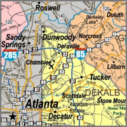
Ideal for all business mapping applications
including marketing, distribution & delivery routes, franchise & sales
territories, property location, service accounts & general reference. Includes
the highway exit numbers, all state, federal and interstate highways, small
towns, major parks, lakes, rivers, airports and more! Super detailed with
named major streets/roads.
Even includes the major highways, cities and counties in the adjoining surrounding states including
areas for Greenville/Spartanburg, Columbia, Charlotte, Chattanooga,
Jacksonville, Tallahassee, Dothan, Panama City. Heat Laminated both sides.
NEW choice of different color/style backgrounds! AND...We can print your company logo on the map at no extra charge, just upload a high resolution .jpg or .pdf of your logo with your order.
LESS CLUTTERED in the same Large Size showing all the highways but without the finer detail of county roads and named major streets, smaller size GEORGIA WALL MAP
ALSO, HERE'S SOME ATLANTA & GEORGIA PUBLIC INFORMATION LINKS...
For traffic info in Georgia 511GA or Atlanta
General site for Georgia State
Your Government | Georgia.gov
Atlanta Regional Commission web site
Atlanta Regional Commission
Ga State energy, land, water resources Georgia Environmental Finance Authority